Occasional unreliable values in PROBA-V Collection 2 TOC Data
Description:
PROBA-V Collection 2 uses an external dataset, namely the MERRA-2 (Modern-Era Retrospective analysis for Research and Applications, version 2) for the inputs of the atmospheric correction (Gelaro et al., 2017). Occasionally, the MERRA-2 dataset contains very high AOT values, leading to unreliable atmospheric correction. The Simplified Model for Atmospheric Correction (SMAC) is inaccurate for AOT above 0.8 (Rahman and Dedieu, 1994).
Impact:
Where the atmospheric correction results in out of range TOC reflectances (<0 or >1) due to the very high AOT inputs, these pixels are flagged in the status map as ‘bad radiometric quality’. However, edge effects around these areas might occur, with subsequent spatial artefacts in downstream products.
Cloud Detection Issue in PROBA-V Collection 1 data
Description:
The modified PROBA-V cloud detection algorithm, which is used in the Collection 1 data, uses monthly land cover information, based on ESA Land Cover CCI data. Each pixel is assigned one of the following classes: ‘land’, ‘water’, ‘snow/ice’, ‘shadow’, ‘cloud’, and ‘unknown’. During the final Collection 1 validation we discovered that during the northern hemisphere winter season the amount of ‘unknown’ land cover assignments is unusually high, which eventually results in a substantial amount of clouds that are labelled ‘clear’.
Impact:
This cloud detection issue impacts both the segment data (Level 2A), as well as the synthesis files at all product resolutions and is most prominent during the northern hemisphere winter season. The underdetection of clouds occurs primarily along a latitudinal band that shifts southward and reaches ~50oN as southernmost position.
We are currently investigating the cause and correction of this issue, further details will be communicated here once available.
This issue was solved in the PROBA-V Collection 2 data set.
Degraded geometric performance
Description:
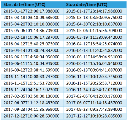
PROBA-V is a very stable platform in terms of geometric performance. It exceeds the mandatory absolute, Inter-bands and multitemporal accuracy by far. However, some occurrences are recorded that the satellite uses the Two Line Element (TLE) in case of a GPS failure leading to degradation of the geometric performance.
On the left is a list of occurrences when the platform used the TLE and degraded performance might be expected.
MVA - 29 August 2018
Due to a special Multiple Viewing Angle (MVA) manoeuvre that was performed over Europe on 29 August 2018, unfortunately no nominal PROBA-V data are available over this area.
Geolocation anomaly for 19 – 21 September 2018
For the period 19 – 21 September 2018, unusually high Absolute Location Errors were observed. We are currently investigating the root cause of this unexpected behavior. All Level 2A segment and S1 data products within the above mentioned time period have been taken offline. The multi-day syntheses for 11 – 20 and 21 – 30 September (S10 products), and for 16 – 20 and 21 – 26 (S5 products) are still available, but do not contain segment data for 19 – 21 September in the calculated composites.
This geolocation issue was traced back to be caused by noisy GPS measurements on the platform, which is difficult to correct for in real time. The geolocation accuracy was back to normal at 21 September after a power cycle.
We apologize for any inconvenience this issue may cause.
Missing Data PROBA-V
No Christmas presents from PROBA-V this year!
Due to an on-board anomaly that occurred on 24/12, nearly two consecutive days of data are not recorded. Data is missing for following dates:
24/12/2018: Most of N-America
25/12/2018: Entire globe
26/12/2018: Entire globe, except for Alaska
To see if any data is missing from your region of interest, following tool can be consulted.
If you have any specific questions or remarks, please contact us at helpdeskticket [at] vgt.vito.be (helpdeskticket[at]vgt[dot]vito[dot]be)
The PROBA-V team